 Wawa-news.com Local and Regional News
 3:36 PM EST Thursday 24 January 2019
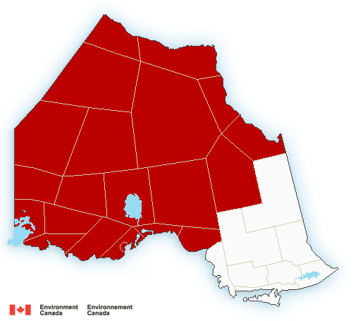
Extreme Cold Warning in effect for:
=New= City Of Thunder Bay
=New= Superior West
=New= Nipigon – Marathon – Superior North
=New= Wawa – White River – Pukaskwa
=New= Kapuskasing – Hearst
Kenora – Nestor Falls
Dryden – Ignace
Fort Frances – Rainy Lake
Atikokan – Upsala – Quetico
Red Lake – Ear Falls
Sioux Lookout – Savant Lake
Lake Nipigon – Wabakimi
Geraldton – Manitouwadge – Hornepayne.
A multi-day episode of very cold wind chills is expected.
A bitterly cold arctic air mass will become established across the area tonight. Extreme wind chills of minus 40 to minus 45 will occur tonight into Friday morning.
This arctic air mass will remain entrenched over the region through the weekend and into early next week, bringing a prolonged period of extremely cold wind chills.
Extreme cold puts everyone at risk.
Dress warmly. Dress in layers that you can remove if you get too warm. The outer layer should be wind resistant.
If it’s too cold for you to stay outside, it’s too cold for your pet to stay outside.

- Trust in trains, government institutions requires public oversight - April 13, 2026
- School Bus Cancellations (Central Algoma Area) Apr 13 - April 13, 2026
- Wawa Mixed Curling – 2026/27 Season Standings - April 10, 2026