Wawa-news.com Local and Regional News
5:04 AM EDT Wednesday 06 April 2022
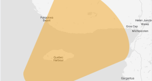
Rainfall warning in effect for:
- Agawa – Lake Superior Park
- Sault Ste. Marie – St. Joseph Island
- Searchmont – Montreal River Harbour – Batchawana Bay
A significant rainfall is expected beginning this afternoon.
Hazards:
Rainfall amounts of 20 to 30 mm that may lead to localized flooding in low-lying areas.
The frozen ground has a reduced ability to absorb this rainfall.
Timing:
This afternoon into tonight.
Discussion:
Total rainfall amounts of 20 to 30 mm will be possible by the time the rain tapers off tonight or Thursday morning.
The partially frozen ground will have a reduced ability to absorb this rainfall and localized flooding in low-lying areas will be possible.
For information concerning flooding, please consult your local Conservation Authority or Ontario Ministry of Northern Development, Mines, Natural Resources and Forestry office. Visit Ontario.ca/floods for the latest details.
Heavy downpours can cause flash floods and water pooling on roads. Localized flooding in low-lying areas is possible.
Orange Alert = Severe weather
Red Alert = Very dangerous and possibly life-threatening weather
For road conditions and other traveller information from the Ministry of Transportation, visit https://www.ontario.ca/511, or call 5-1-1.
Please continue to monitor alerts and forecasts issued by Environment Canada. To report severe weather, send an email to [email protected] or tweet reports using #ONStorm.
- Heat Warning (White River – Dubreuilville) - June 29, 2026
- Heat Warning (Chapleau – Missinaibi Lake) - June 29, 2026
- Heat Warning (Gogama – Foleyet) - June 29, 2026