Tag Archives: TIM002

Northeast Forest Fire Update – June 11

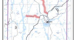
As of the early evening of June 11, there are three active wildland fires in the region. Chapleau 4 is located north of Hwy 101 between Timmins and Chapleau. It is being held at 16.5 hectares. Sudbury 2 is under control at 0.2 of a hectare, on the southwest side of Windy Lake. Timmins 2 was remapped at 5622 hectares on ...

Read More »

Northeast Forest Fire Update- June 11

As of the early evening of June 10, there are four active wildland fires in the region. Chapleau 4 is located north of Hwy 101 between Timmins and Chapleau. It is being held at 16.5 hectares. Sudbury 2 is under control at 0.2 of a hectare, on the southwest side of Windy Lake. Sudbury 6 is under control at 0.5 of ...

Read More »

TIM002 UPDATE – June 9

Timmins Forest Fire 2 (referred to as TIM002) was confirmed on June 6, 2019. This evening, June 9, 2019, the Ministry of Natural Resources and Forestry (MNRF) estimated TIM002 to be 6,000 hectares. The fire is approximately 4 kilometres west of the community of Gogama, and burning on the west side of Highway 144, running parallel to the roadway. It’s ...

Read More »

Northeast Forest Fire Update – June 9

By the time this report was created there were two new fires in the Northeast Region. Sudbury 6 is located on the south shore of the French River, approximately eight kilometres southeast of Ouellette. The 0.2 hectare fire is not under control. Parry Sound 3 is located approximately 11 kilometres northeast of Britt. The fire is out at 0.1 hectares. ...

Read More »