Wawa-news.com Local and Regional News
Apr 12, 2026 at 07:01
Ponding along Wawa Lake (March 23rd, 2026).
On April 10th, the Surface Water Monitoring Centre, Ministry of Natural Resources issued a Flood Watch for MNR Districts Chapleau/Wawa and Sault Ste. Marie (full list is below). With rain expected over the next 5 days with toral amounts ranging from 25 to 60 mm of rainfall expected. The most significant precipitation and milder conditions are expected on Sunday and Tuesday.
An Alberta Clipper is forecast to track across the province, bringing rain and showers particularly around the Great Lakes and west of Lake Superior. Rain from 10 to 30 mm likely, with higher amounts along Lake Superior.
Wawa and area residents have been experiencing greater amounts of ponding on local roadways. Within the Municipality, the Infrastructure department has been busy working to clear drains and allow the water to drain off the streets. An area of difficulty that the department is tackling is along the Harbour Road, especially from Long Beach Road, Sandy Beach and Mud Lake.
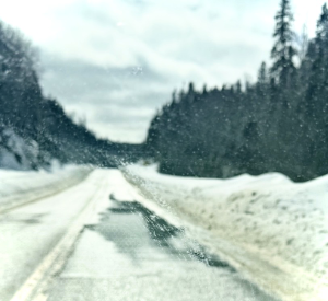
Along Hwy 17, 101, and area seconday highways, significant ponding has been taking place, with stretches of water from yellow line to fog line and even completely across the highway at times. The MTO has been winging back banks, and cutting holes in the banks to help drainage. Please be very careful while driving through water – there are many potholes developing, and some may be hidden under the water’s surface.
 Provincial Flood Watch for Southern and Northeast Regions, and Watershed Conditions Statement for Northwest Region Issued by the Surface Water Monitoring Centre, Ministry of Natural Resources on April 10th, 2026, at 3:30 p.m.
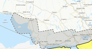
MNR Districts: Aurora Midhurst Owen Sound, Chapleau Wawa, Dryden Fort Frances Atikokan, Kemptville Kingston, Kenora, Minden Parry Sound Bracebridge, Nipigon Geraldton, North Bay, Pembroke, Peterborough Bancroft, Red Lake Sioux Lookout, Sault Ste Marie Blind River, Sudbury, Thunder Bay Ignace, Timmins Kirkland Lake
Conservation Authorities
Ausable Bayfield, Conservation Sudbury, Crowe Valley, Ganaraska Region, Grey Sauble, Kawartha Region, Lake Simcoe Region, Lakehead Region, Lower Trent, Mattagami Region, Mississippi Valley, North Bay-Mattawa, Nottawasaga Valley, Otonabee Region, Quinte, Rideau Valley, Saugeen Valley, Sault Ste. Marie Region
Weather situation
The 5 day forecast continues to indicate widespread precipitation across the Great Lakes region, with total amounts generally ranging from 25 to 60 mm. The most significant precipitation and milder conditions are expected on Sunday and Tuesday.
Sunday:
An Alberta Clipper is forecast to track across the province, bringing rain and showers particularly around the Great Lakes and west of Lake Superior.
- Southern Region: Widespread rainfall of 15 to 25 mm, locally heavier near Georgian Bay, under mild temperatures.
- Northeast Region: Rain from 10 to 30 mm likely, with higher amounts along Lake Superior and Georgian Bay shores.
- Northwest Region: Rain and showers or 10 to 25 mm extending from western areas toward the James Bay coast, with seasonably mild conditions.
Tuesday:
A southwesterly flow and associated warm front is expected to move into the province, bringing another round of widespread precipitation, mainly affecting southern and eastern Ontario.
- Southern and Northeast Regions: Periods of rain, with totals of 10 to 25 mm, and continued mild temperatures.
- Northwest Region: 0 to 5 mm of precipitation, with above freezing conditions.
Risks:
Water levels and flows have elevated for much of southern Ontario and southern parts of Northeast Region. Areas around mid-central southern Ontario, Muskoka-French River, and Sudbury and North Bay to Sault Ste. Marie areas are showing increasing trends from snowmelt and rainfall. In Northwest District levels and flows are beginning to increase in areas along the Rainy River, Lake Superior coast and toward Moosonee but remain seasonal.
The latest provincial snow survey completed April 1st indicates frozen ground and snow‑water‑equivalent (SWE) values of roughly 25–100+ mm across the Muskokas, north-Trent–Severn watershed, Crowe, Mississippi and Quinte, and northward into Northeast and Northwest Regions. The snowpack is ripening south of the Algonquin Park area. Rainfall and warm temperatures will increase the density of the snowpack where it occurs. Frozen ground conditions will limit soil infiltration; as a result, rainfall and any additional snowmelt in the coming days will continue to generate significant surface runoff.
Water levels and flows are anticipated to be high over the coming days in Southern and Northeast Regions. In southern parts of Northwest Region, runoff may increase over the weekend raising flows and levels.
Close monitoring of local forecasts, special weather statements, and warnings is recommended.
This message will remain in effect until Monday April 13th at 3:00 p.m., unless otherwise updated.

- Provincial Flood Watch (Chapleau, Wawa, Sault Ste Marie) - April 11, 2026
- Public has 30 days to Comment on Nuclear Waste Transportation and Burial Plan - April 11, 2026
- Saturday Morning News – April 11 - April 11, 2026