 Wawa-news.com Local and Regional News
Dec 25, 2025 at 08:06
Impact Level: Moderate
Forecast Confidence: High
Significant snowfall continues.
What:
- Total snowfall amounts of 15 to 20 cm, with locally higher amounts possible near Lake Superior.
- Reduced visibility in heavy snow and local blowing snow.
When: Ending later this morning.
Additional information: Areas near Lake Superior will also see local blowing snow with winds gusting up to 60 km/h. Snow is expected to taper to flurries later this morning.
Travel will likely be challenging. Visibility will likely be reduced at times. Allow extra time for travel.
Dec 25, 2025 at 22:32
Impact Level: Moderate
Forecast Confidence: High
Significant snowfall continues.
What:
- Snowfall amounts of 15 to 20 cm, with locally higher amounts possible near Lake Superior.
- Reduced visibility in heavy snow and local blowing snow.
When: Continuing tonight and ending Friday morning.
Additional information: Areas near Lake Superior will also see local blowing snow with winds gusting up to 60 km/h. Snow is expected to taper to flurries by Friday morning for most regions, except closer to noon for Wawa.
Travel will likely be challenging. Visibility will likely be reduced at times. Allow extra time for travel.
Please continue to monitor alerts and forecasts issued by Environment Canada.
Dec 25, 2025 at 21:06
 Impact Level: Moderate
Forecast Confidence: High
Significant snowfall continues.
What:
- Snowfall amounts of 15 to 20 cm, with locally higher amounts possible near Lake Superior.
- Reduced visibility in heavy snow and local blowing snow.
When: Continuing this evening and ending Friday morning.
Additional information: Areas near Lake Superior will also see local blowing snow with winds gusting up to 60 km/h.
Snow is expected to taper to flurries by Friday morning for most regions, except closer to noon for Wawa. Travel will likely be challenging. Visibility will likely be reduced at times. Allow extra time for travel.
Please continue to monitor alerts and forecasts issued by Environment Canada.
To report severe weather, send an email to [email protected] or post reports on X using #ONStorm.
Dec 24, 2025 at 19:47
 Impact Level: Moderate
Forecast Confidence: High
Significant snowfall Thursday night.
What:
- Snowfall amounts of 15 to 20 cm, with locally higher amounts possible near Lake Superior.
- Reduced visibility in heavy snow and local blowing snow.
When: Beginning Thursday evening and ending Friday morning.
Additional information: Snow, heavy at times, is expected to move into the region Thursday night. Areas near Lake Superior will also see local blowing snow with winds gusting up to 50 km/h. Snow is expected to taper to flurries by Friday morning for most regions, except closer to noon for Wawa.
Travel will likely be challenging. Roads and walkways will likely be difficult to navigate due to accumulating snow. Visibility will likely be reduced at times. Allow extra time for travel. Please continue to monitor alerts and forecasts issued by Environment Canada.
To report severe weather, send an email to [email protected] or post reports on X using #ONStorm. For more information about the alerting program, please visit: Colour-coded Weather Alerts.
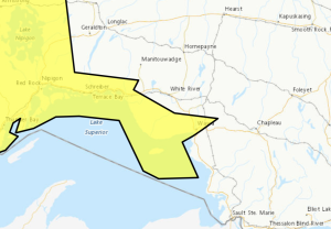
In effect for:
- Wawa – Pukaskwa Park
Orange Alert = Severe weather
Red Alert = Very dangerous and possibly life-threatening weather
For road conditions and other traveller information from the Ministry of Transportation, visit https://www.ontario.ca/511, or call 5-1-1.
Please continue to monitor alerts and forecasts issued by Environment Canada. To report severe weather, send an email to [email protected] or tweet reports using #ONStorm.
- Snowfall Today (Wawa – Pukaskwa Park) - April 4, 2026
- Snowfall Today (Marathon – Schreiber) - April 4, 2026
- Winter Storm Today (Chapleau – Missinaibi Lake) - April 4, 2026
