Wawa-news.com Local and Regional News
Weather – Mainly cloudy with 30 percent chance of flurries this morning. Snow beginning near noon. Amount 2 to 4 cm. Wind up to 15 km/h. High minus 4. Wind chill minus 14 this morning and minus 8 this afternoon. UV index 1 or low.
Tonight – Snow. Amount 10 cm. Wind becoming northwest 20 km/h gusting to 40 before morning. Low minus 6. Wind chill near minus 12.
Special weather statement in effect for:
Wawa – Pukaskwa Park
White River – Dubreuilville
Snow beginning this afternoon.
Snow associated with a low pressure system will move into the area this afternoon. Snowfall amounts of 10 to 15 cm are likely by the time the snow tapers off early Monday morning.
If higher snowfall amounts are anticipated a snowfall warning may be required.
Snow squall watch in effect for:
- Agawa – Lake Superior Park
- Sault Ste. Marie – St. Joseph Island
- Searchmont – Montreal River Harbour – Batchawana Bay
Snow squalls expected overnight into Monday.
Snow associated with an approaching weather system will affect regions near Lake Superior this afternoon and evening with several centimetres likely. After the system passes overnight, increasing northwest winds will result in the development of lake effect flurries and snow squalls which will persist into Monday.
Snowfall accumulations of 15 to 25 cm will be possible in some areas from tonight until late Monday. In addition, northwest winds gusting to 70 km/h will result in areas of blowing snow giving very poor visibility.
Visibility may be suddenly reduced at times in heavy snow. Surfaces such as highways, roads, walkways and parking lots may become difficult to navigate due to accumulating snow. Consider postponing non-essential travel until conditions improve.
News Tidbits – Wawa’s Emma Ward has been nominated for this years Faces Award in Ottawa. The social media component means that her friends must click and vote for her – the link is here!

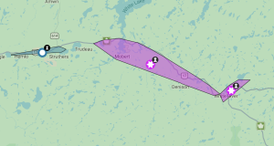
- Power Outage in White River, Mobert and Hemlo - July 29, 2026
- Wednesday Morning New – July 29th - July 29, 2026
- Tuesday Morning News – July 28th - July 28, 2026