Wawa-news.com Local and Regional News
Jul 6, 2017 @ 11:18
 11:13 AM EDT Thursday 06 July 2017
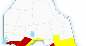
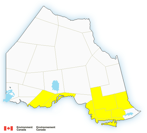
Severe thunderstorm watch in effect for:
- Agawa – Lake Superior Park
- Chapleau – Missinaibi Lake
- Gogama – Foleyet
- Sault Ste. Marie – St. Joseph Island
- Searchmont – Montreal River Harbour – Batchawana Bay
Conditions are favourable for the development of dangerous thunderstorms that may be capable of producing damaging wind gusts and large hail.
A cluster of thunderstorms over Upper Michigan is expected to move eastwards into the Sault Ste Marie area early this afternoon. Additional new thunderstorms are also expected to form this afternoon over Northeastern Ontario. Any of these thunderstorms have the potential to become severe.
Very strong wind gusts can damage buildings, down trees and blow large vehicles off the road. Be prepared for severe weather. Take cover immediately, if threatening weather approaches. Lightning kills and injures Canadians every year. Remember, when thunder roars, go indoors!
Severe thunderstorm watches are issued when atmospheric conditions are favourable for the development of thunderstorms that could produce one or more of the following: large hail, damaging winds, torrential rainfall.
The Office of the Fire Marshal and Emergency Management recommends that you take cover immediately if threatening weather approaches.
Please continue to monitor alerts and forecasts issued by Environment Canada. To report severe weather, send an email to [email protected] or tweet reports using #ONStorm.Thnd

- Tuesday Morning News – July 21st - July 21, 2026
- Monday Morning News – July 20th - July 20, 2026
- Wawa FD called to Backyard Bonfire during RFZ - July 19, 2026