Wawa-news.com Local and Regional News
Special weather statements in effect for:
 Chapleau – Gogama
- Elliot Lake – Ranger Lake
- Greater Sudbury and vicinity
- Kirkland Lake – Temiskaming Shores – Temagami
- Manitoulin – Blind River – Killarney
- Nipigon – Marathon – Superior North
- North Bay – West Nipissing
- Sault Ste. Marie – Superior East
- Timmins – Cochrane
- Wawa – White River – Pukaskwa
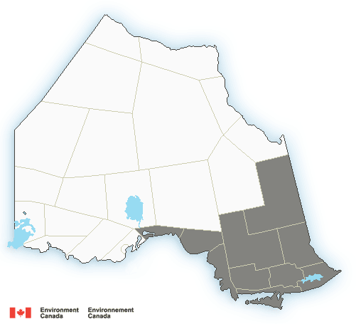
Snow on the way beginning this evening into tonight.
A low-pressure system will emerge from Texas and track towards the Great Lakes today. This low will bring an area of snow with it, arriving this evening near the shores of Lake Superior or tonight north of Lake Huron. Total snowfall amounts near 15 cm will be possible by the time the snow moves out of the area Tuesday morning. Snowfall warnings may be required.
There is some uncertainty as to the exact track of the low, which will affect how much snow falls at a particular location.
Poor winter driving conditions are expected beginning this evening. Motorists should be prepared to adjust their travel plans accordingly.

This is a media release by the organization. If you would like to send Wawa-news.com a media release to be published, send it to Brenda Stockton, Editor/Publisher, [email protected]
Latest posts by This Media Release (see all)
- Men’s Night Golf – June 12 - June 13, 2026
- Northeast Forest Fire Region Update – June 12 - June 13, 2026
- Northeast Forest Fire Region Update – June 11 - June 12, 2026