Wawa-news.com Local and Regional News
Updated restrictions in effect – Fort Frances 14
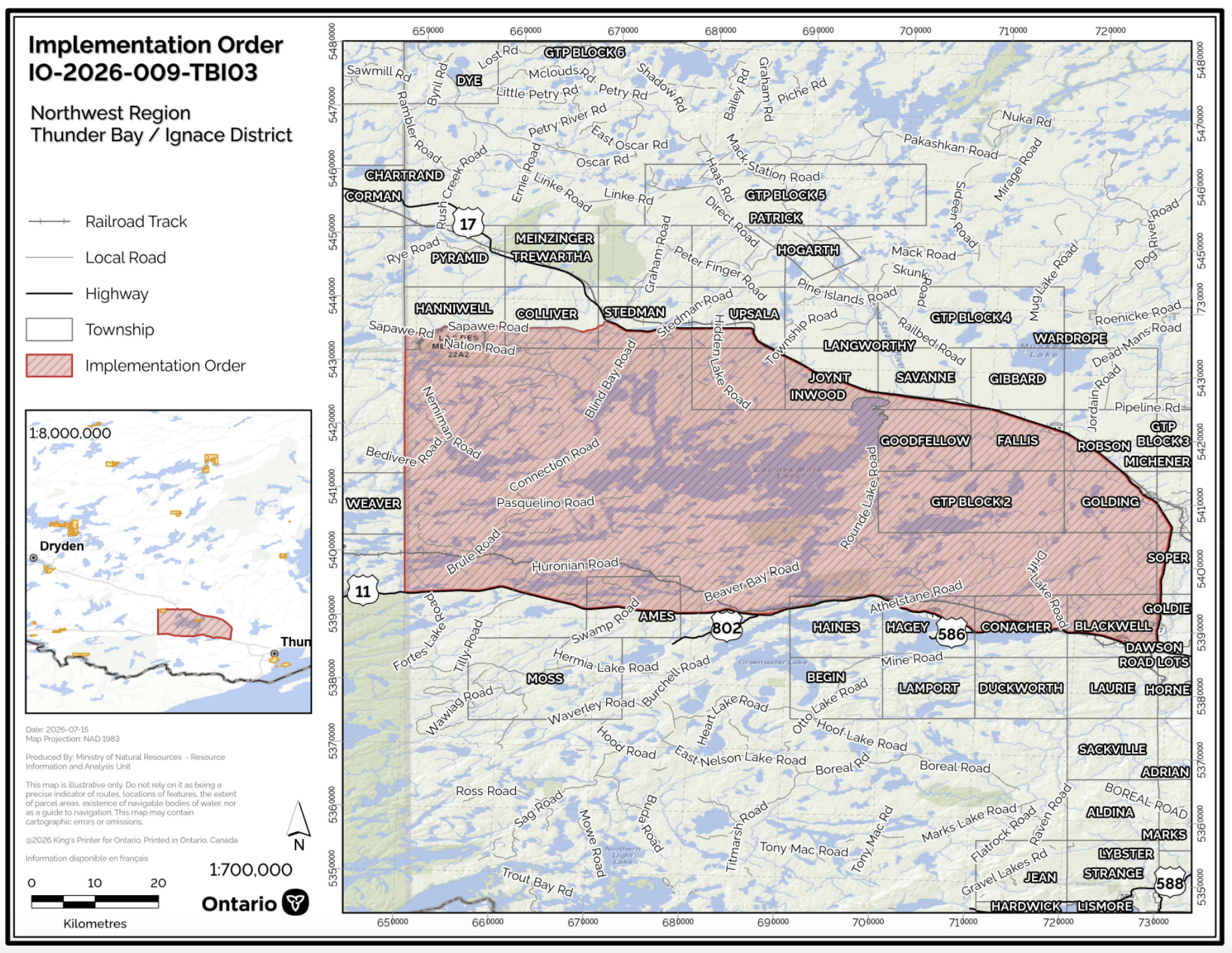
The Ministry of Natural Resources’ Thunder Bay – Ignace has invoked an Implementation Order now in effect for the purposes of public safety and fire suppression, for areas near Fort Frances 14, under the Emergency Area Order EAO 2026-09 declared on July 17, 2026.
All travel and use of as outlined in the identified area on the attached Implementation Order map within the EAO is prohibited unless authorized by a permit to engage in specified activities issued by the Thunder Bay-Ignace District of the Ministry of Natural Resources (MNR). These include:
- Athelstane Road, Blind Bay Road, Chief Peter Lake Road, Crayfish Road, Davidson Road, Dexter Road, Gonyou Road, Hay Lake Road (South of Highway17), Huronian Road, Inwood Township Road, J.D. Hackman Road, Kashabowie Road, Lac Des Mille Lac Road, Lily Lake Road, Pipeline Road, Sapawe Road, Sawmill Bay Road, Seine East Road, Seine River Road, Stetham Lake Road, and Upsala Road
All modes of travel/access into and all Crown lands as outlined in the identified area on the attached Implementation Order map within the EAO is prohibited unless authorized by a permit to engage in specified activities issued by the Thunder Bay – Ignace District of the MNR. These include:
- Atikokan River, Beaver River, Boundary Lake, East Divide Lake, Firesteel River, Hay River, Huronian Lake, Inwood Creek, Inwood Lake, Kashabowie Lake, Kashabowie River, Lac des Mille Lac, Little Kabaigon Lake, Little Savanne River, McKay Creek, Mud Lake, Nemiman Lake, Obadinaw River, Postans Lake, Savanne River, Seine River, Sitches Lake, Union Lake, Upsala Creek, and Windigoostigwan Lake
This Order is in effect at 12:01 a.m. Eastern Daylight Time on July 17, 2026 until such time as the order is revoked.
For more information on this Implementation Order, please call 807-475-1471