Wawa-news.com Local and Regional News
Nov 26, 2025 at 06:01
| Agawa – Lake Superior Park | Continuing today, ending Thursday afternoon or night. | Total snowfall amounts of 30 to 60 cm. | Peak snowfall rates of 2 to 4 cm per hour. | Near zero visibility at times in heavy snow and blowing snow. |
| Marathon – Schreiber | Today through Thursday morning. | Total snowfall amounts of 15 to 30 cm. | Strong northerly winds gusting up to 70 km/h will also accompany the snow, leading to blowing snow and reduced visibility to near zero at times. | |
| Wawa – Pukaskwa Park | Continuing today, ending Thursday afternoon or night. | Total snowfall amounts of 30 to 60 cm. | Peak snowfall rates of 2 to 4 cm per hour. | Near zero visibility at times in heavy snow and blowing snow. |
| White River – Dubreuilville | Continuing today, ending Thursday afternoon or night. | Total snowfall amounts of 30 to 60 cm. | Peak snowfall rates of 2 to 4 cm per hour. | Near zero visibility at times in heavy snow and blowing snow. |
Nov 25, 2025 at 21:29
Nov 25, 2025 at 12:49
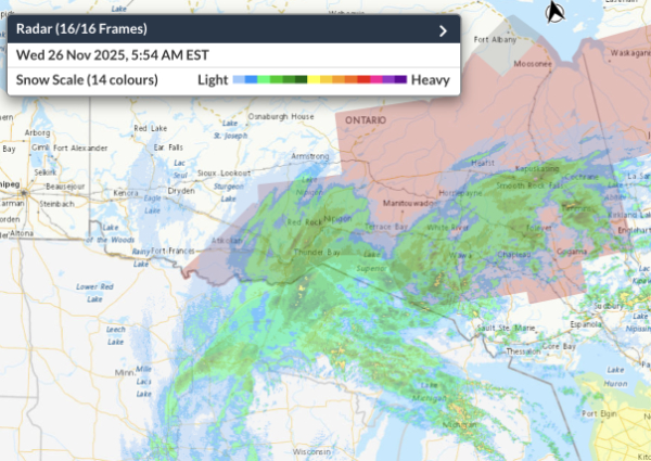
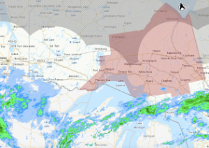
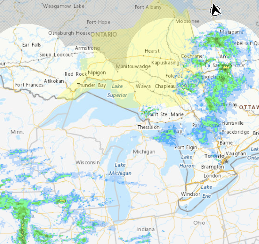
The winter storm warnings continue with updated amounts of snow expected (30 to 60cm) through the Lake Superior to Kapuskasing corridor (from Environment Canada at 10:24 a.m.):
| East Thunder Bay | Kakabeka Falls – Whitefish Lake – Arrow Lake | Beginning this evening and ending Wednesday night. | 10 to 20 cm | Strong northerly winds gusting up to 70 km/h |
| Hwy 101 Corridor | Chapleau – Missinaibi Lake | Beginning tonight and ending Thursday or Thursday night. | Total snowfall amounts of 30 to 60 cm. | Strong northerly winds |
| Hwy 101 Corridor | Gogama – Foleyet | Tonight through Thursday. | 15 to 20 cm. (turning to rain Wednesday aft.) | gusty northerly winds |
| Hwy 11 Corridor | Beardmore – Jellicoe – Macdiarmid | Beginning this evening and ending Wednesday night. | Total snowfall amounts of 15 to 25 cm. | Strong northerly winds gusting up to 70 km/h |
| Hwy 11 Corridor | Geraldton – Longlac – Caramat | Beginning tonight and ending Thursday morning. | Total snowfall amounts of 15 to 25 cm. | Strong northerly winds gusting up to 70 km/h |
| Hwy 11 Corridor | Kapuskasing – Hearst – Smooth Rock Falls | Beginning tonight and ending Thursday or Thursday night. | Total snowfall amounts of 30 to 60 cm. | Strong northerly winds will accompany the snow |
| Hwy 11 Corridor | Kirkland Lake – Englehart | Tonight through Thursday. | 15 to 20 cm. (turning to rain Wednesday aft.) | gusty northerly winds |
| Hwy 11 Corridor | Timmins – Cochrane – Iroquois Falls | Beginning tonight and ending Thursday or Thursday night. | Total snowfall amounts of 30 to 60 cm. | Strong northerly winds will accompany the snow, |
| Hwy 11/17 Corridor | City of Thunder Bay | Beginning this evening and ending Wednesday night. | 10 to 20 cm | Strong northerly winds gusting up to 70 km/h |
| Hwy 11/17 Corridor | Cloud Bay – Dorion | Beginning this evening and ending Wednesday night. | 10 to 20 cm | Strong northerly winds gusting up to 70 km/h |
| Hwy 17 Corridor | Agawa – Lake Superior Park | Beginning tonight and ending Thursday or Thursday night. | Total snowfall amounts of 30 to 60 cm. | Strong northerly winds |
| Hwy 17 Corridor | Marathon – Schreiber | Beginning tonight and ending Thursday morning. | Total snowfall amounts of 15 to 25 cm. | Strong northerly winds gusting up to 70 km/h |
| Hwy 17 Corridor | Nipigon – Rossport | Beginning this evening and ending Wednesday night. | Total snowfall amounts of 15 to 25 cm. | Strong northerly winds gusting up to 70 km/h |
| Hwy 17 Corridor | Wawa – Pukaskwa Park | Beginning tonight and ending Thursday or Thursday night. | Total snowfall amounts of 30 to 60 cm. | Strong northerly winds will accompany the snow |
| Hwy 17 Corridor | White River – Dubreuilville | Beginning tonight and ending Thursday or Thursday night. | Total snowfall amounts of 30 to 60 cm. | Strong northerly winds will accompany the snow |
| Hwy 631 & 614 | Manitouwadge – Hornepayne | Beginning tonight and ending Thursday or Thursday night. | Total snowfall amounts of 30 to 60 cm. | Strong northerly winds |
| James Bay | Fort Albany | Beginning Wednesday evening and ending Friday morning. | Total snowfall amounts of 15 to 20 cm. | Strong northerly winds will increase on Thursday, with gusts up to 70 km/h |
| James Bay | Little Abitibi – Kesagami Lake | Beginning Wednesday and ending Thursday night or Friday morning. | Total snowfall amounts of 30 to 60 cm with higher amounts possible. | Strong northerly winds will increase on Thursday, with gusts up to 70 km/h |
Nov 25, 2025 at 06:04
| Start | Snowfall | Wind | ||||
| East Thunder Bay | Kakabeka Falls – Whitefish Lake – Arrow Lake | Beginning this evening and ending Wednesday night. | 10 to 20 cm | Strong northerly winds gusting up to 70 km/h | ||
| Hwy 101 Corridor | Chapleau – Missinaibi Lake | Beginning tonight and ending Thursday or Thursday night. | 25 to 45+ cm | Strong northerly winds | ||
| Gogama – Foleyet | Tonight through Thursday. | 15 to 20 cm. (turning to rain Wednesday aft.) | gusty northerly winds | |||
| Hwy 11 Corridor | Beardmore – Jellicoe – Macdiarmid | Beginning this evening and ending Wednesday night. | 10 to 20 cm | Strong northerly winds gusting up to 70 km/h | ||
| Geraldton – Longlac – Caramat | Beginning tonight and ending Thursday morning. | 15 to 25 cm. | Strong northerly winds gusting up to 70 km/h | |||
| Kapuskasing – Hearst – Smooth Rock Falls | Beginning tonight and ending Thursday or Thursday night. | 25 to 45+ cm | Strong northerly winds will accompany the snow | |||
| Kirkland Lake – Englehart | Tonight through Thursday. | 15 to 20 cm. (turning to rain Wednesday aft.) | gusty northerly winds | |||
| Timmins – Cochrane – Iroquois Falls | Beginning tonight and ending Thursday or Thursday night. | 25 to 45+ cm | Strong northerly winds will accompany the snow, | |||
| Hwy 11/17 Corridor | City of Thunder Bay | Beginning this evening and ending Wednesday night. | 10 to 20 cm | Strong northerly winds gusting up to 70 km/h | ||
| Cloud Bay – Dorion | Beginning this evening and ending Wednesday night. | 10 to 20 cm | Strong northerly winds gusting up to 70 km/h | |||
| Hwy 17 Corridor | Agawa – Lake Superior Park | Beginning tonight and ending Thursday or Thursday night. | 25 to 45+ cm | Strong northerly winds | ||
| Marathon – Schreiber | Beginning tonight and ending Thursday morning. | 15 to 20 cm | Strong northerly winds gusting up to 70 km/h | |||
| Nipigon – Rossport | Beginning this evening and ending Wednesday night. | 10 to 20 cm | Strong northerly winds gusting up to 70 km/h | |||
| Nipigon – Rossport | Beginning this evening and ending Wednesday night. | 10 to 20 cm | Strong northerly winds gusting up to 70 km/h | |||
| Wawa – Pukaskwa Park | Beginning tonight and ending Thursday or Thursday night. | 25 to 45+ cm | Strong northerly winds will accompany the snow | |||
| White River – Dubreuilville | Beginning tonight and ending Thursday or Thursday night. | 25 to 45+ cm | Strong northerly winds will accompany the snow | |||
| Hwy 631 & 614 | Manitouwadge – Hornepayne | Beginning tonight and ending Thursday or Thursday night. | 25 to 45+ cm | Strong northerly winds | ||
| James Bay | Fort Albany | Beginning Wednesday evening and ending Friday morning. | 15 to 20 cm | Strong northerly winds will increase on Thursday, with gusts up to 70 km/h | ||
| Little Abitibi – Kesagami Lake | Beginning Wednesday and ending Thursday night or Friday morning. | 25 to 45 cm | Strong northerly winds will increase on Thursday, with gusts up to 70 km/h | |||
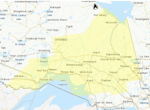
 Major winter storm with heavy snow and blowing snow is expected.
Total snowfall amounts of 25 to 45 cm with higher amounts possible.
Significantly reduced visibility, to near zero at times, in heavy snow and blowing snow.
Beginning tonight and ending Thursday or Thursday night.
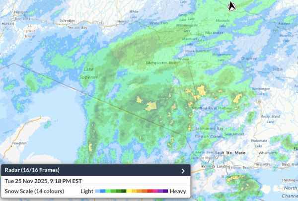
Strong northerly winds will accompany the snow, leading to blowing snow and reduced visibility to near zero at times. The heaviest snow is expected on Wednesday. Total snowfall amounts may exceed 50 cm for some locales northeast of Lake Superior.
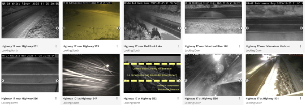
Travel will likely be hazardous. Road closures are possible.
Avoid non-essential travel and outdoor activities. Prepare for disruptions to transportation, services and utilities.
The above report was issued for Wawa. The report for other areas are similar with variations in wind velocities and snow amounts. Please check your area for the detailed report.
Nov 24, 2025 at 18:24
 Wawa – Pukaskwa Park (25-35cm)
- Agawa – Lake Superior Park (25-35cm)
- White River – Dubreuilville (25-35cm)
- Chapleau – Missinaibi Lake (25-35cm)
- Chapleau – Missinaibi Lake (25-35cm)

- Atikokan – Shebandowan – Quetico Park
- Beardmore – Jellicoe – Macdiarmid (near 15cm)
- City of Thunder Bay (near 15cm)
- Cloud Bay – Dorion (near 15cm)
- Fort Albany (15 to 25 cm)
- Fraserdale – Pledger Lake (15 to 25 cm)
- Geraldton – Longlac – Caramat (15 to 25 cm)
- Gogama – Foleyet (15 to 20 cm)
- Kakabeka Falls – Whitefish Lake – Arrow Lake (near 15cm)
- Kapuskasing – Hearst – Smooth Rock Falls (25-35cm)
- Kirkland Lake – Englehart (15 to 20 cm)
- Little Abitibi – Kesagami Lake (15 to 25 cm)
- Manitouwadge – Hornepayne (25-35cm)
- Marathon – Terrace Bay – Schreiber (15 to 25 cm)
- Moosonee (15 to 25 cm)
- Nakina – Aroland – Pagwa (15 to 25 cm)
- Nipigon – Rossport (near 15cm)
- Timmins – Cochrane – Iroquois Falls (25-35cm)
- Heavy snow and blowing snow are expected.
- Total snowfall amounts of 25 to 35 cm.
- Reduced visibility in heavy snow and blowing snow.
Beginning Tuesday night and ending from west to east through the day on Thursday.
Strong northerly winds will also accompany the snow, leading to blowing snow and reduced visibility to near zero at times. Total snowfall amounts may reach 40 cm for some locales northeast of Lake Superior.
Travel will likely be hazardous. Road closures are possible. Avoid non-essential travel and outdoor activities. Be very careful if walking or driving. Prepare for disruptions to transportation, services and utilities.
Nov 24, 2025 at 14:39
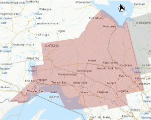
 Winter Storm Watch in effect for:
- Wawa – Pukaskwa Park
- Agawa – Lake Superior Park
- White River – Dubreuilville
- Chapleau – Missinaibi Lake
- Chapleau – Missinaibi Lake
- Atikokan – Shebandowan – Quetico Park
- Beardmore – Jellicoe – Macdiarmid
- City of Thunder Bay
- Cloud Bay – Dorion
- Fort Albany
- Fraserdale – Pledger Lake
- Geraldton – Longlac – Caramat
- Gogama – Foleyet
- Gull Bay – Black Sturgeon Lake
- Kakabeka Falls – Whitefish Lake – Arrow Lake
- Kapuskasing – Hearst – Smooth Rock Falls
- Kirkland Lake – Englehart
- Little Abitibi – Kesagami Lake
- Manitouwadge – Hornepayne
- Marathon – Schreiber
- Moosonee
- Nakina – Aroland – Pagwa
- Nipigon – Rossport
- Timmins – Cochrane – Iroquois Falls
- Upsala – Raith
- Hazardous winter conditions are possible.
- Heavy snow and blowing snow are expected.
- Total snowfall amounts of 25 to 40 cm.
- Reduced visibility in heavy snow and blowing snow.
Beginning Tuesday night and ending from west to east through the day on Thursday.
Strong northerly winds will also accompany the snow, leading to blowing snow and reduced visibility to near zero at times. Total snowfall amounts may exceed 40 cm for some locales northeast of Lake Superior. Roads and walkways may be difficult to navigate. Road closures are possible.
Local utility outages are possible.
Consider rescheduling travel and outdoor activities.
Nov 24, 2025 at 08:27
This watch continues as of 8:18 a.m.
 Wawa – Pukaskwa Park
- Agawa – Lake Superior Park
- White River – Dubreuilville
- Chapleau – Missinaibi Lake
- Chapleau – Missinaibi Lake
- Atikokan – Shebandowan – Quetico Park
- Beardmore – Jellicoe – Macdiarmid
- City of Thunder Bay
- Cloud Bay – Dorion
- Fort Albany
- Fraserdale – Pledger Lake
- Geraldton – Longlac – Caramat
- Gogama – Foleyet
- Gull Bay – Black Sturgeon Lake
- Kakabeka Falls – Whitefish Lake – Arrow Lake
- Kapuskasing – Hearst – Smooth Rock Falls
- Kirkland Lake – Englehart
- Little Abitibi – Kesagami Lake
- Manitouwadge – Hornepayne
- Marathon – Schreiber
- Moosonee
- Nakina – Aroland – Pagwa
- Nipigon – Rossport
- Timmins – Cochrane – Iroquois Falls
- Upsala – Raith
Heavy snow and blowing snow is expected. Total snowfall amounts of 15 to 30 cm. Reduced visibility in heavy snow and blowing snow.
Beginning Tuesday night and ending from west to east through the day on Thursday.
Strong northerly winds will also accompany the snow, leading to possible blowing snow that could reduce visibility to near zero at times. There remains uncertainty with the exact track of the low pressure system, and therefore the corridor of heaviest snowfall.
Total snowfall amounts may exceed 30 cm for some locations north of Lake Superior.
Roads and walkways may be difficult to navigate. Visibility may be suddenly reduced to near zero at times. Road closures are possible. Consider rescheduling travel and outdoor activities.
Editor’s Note: A Winter Storm Watch means that all the factors and indicators are in place for a Winter storm to occur. When the storm begins this Watch will become a Storm Warning.
Orange Alert = Severe weather
Red Alert = Very dangerous and possibly life-threatening weather
For road conditions and other traveller information from the Ministry of Transportation, visit https://www.ontario.ca/511, or call 5-1-1.
Please continue to monitor alerts and forecasts issued by Environment Canada. To report severe weather, send an email to [email protected] or tweet reports using #ONStorm.
- Yellow Warning – Freezing Rain for (Manitouwadge – Hornepayne) ENDED - May 19, 2026
- Severe Thunderstorm Alerts for: Agawa – Lake Superior Park (ENDED) - May 18, 2026
- Significant rainfall expected (Pukaskwa Park – Blind River) - April 28, 2026