Wawa-news.com Local and Regional News
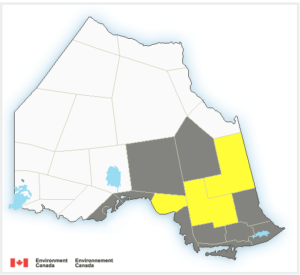
Areas in yellow are under the Winter Storm Warning.
Winter storm watch is in effect for:
- Wawa – Pukaskwa Park
- White River – Dubreuilville
- Chapleau – Missinaibi Lake
- Timmins – Cochrane – Iroquois Falls
Environment Canada is warning of a winter storm as a Colorado Low approaches the region. The storm is expected to begin with snow Saturday morning or afternoon. To make this extremely yucky, the snow is expected to change to freezing rain or ice pellets Saturday night into Sunday morning before changing back to snow Sunday afternoon. Total snowfall accumulations of 10 to 20 cm are possible by Sunday evening. Ice accretion of 2 to 5 mm is also possible.
This storm is expected to create hazardous winter travelling conditions, “Rapidly accumulating snow could make travel difficult over some locations. Surfaces such as highways, roads, walkways and parking lots may become icy and slippery.”
Poor weather is expected for most of Northern Ontario this weekend. In addition:
Significant Snowfall (15-20cm) is expected for:
- City Of Thunder Bay
- Superior West
- Manitouwadge – Hornepayne
- Nipigon – Marathon – Superior North
- Kapuskasing – Hearst
- Little Abitibi – Kesagami Lake
Winter Storm & Freezing Rain:
- Agawa – Lake Superior Park
Freezing Rain & Snow:
- Searchmont – Montreal River Harbour – Batchawana Bay
- Sault Ste. Marie – St. Joseph Island
- Greater Sudbury And Vicinity
- Elliot Lake – Ranger Lake
- Blind River – Thessalon
- Espanola – Killarney
- North Bay – West Nipissing

- LSPP – Gargantua Road Closed - June 24, 2026
- Wednesday Morning News – June 24 - June 24, 2026
- Tuesday Morning News – June 23 - June 23, 2026