Wawa-news.com Local and Regional News
Jul 30, 2017 @ 22:35
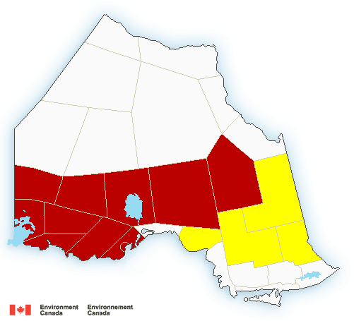
Severe thunderstorm watch (continues 10:21 p.m.) in effect for:
- Chapleau – Gogama
- Kirkland Lake – New Liskeard – Tegagami
- Timmins – Cochrane
Jul 30, 2017 @ 11:22
 11:17 AM EDT Sunday 30 July 2017
Severe thunderstorm watch in effect for:
- White River – Dubreuilville (ended 10:21 p.m.)
- Chapleau (continues 10:21 p.m.)
- Missinaibi Lake
- Gogama (continues 10:21 p.m.)
- Foleyet
- Kirkland Lake (continues 10:21 p.m.)
- Englehart
- New Liskeard – Temagami (continues 10:21 p.m.)
- Little Abitibi – Kesagami Lake (ended 10:21 p.m.)
- Timmins – Cochrane – Iroquois Falls (continues 10:21 p.m.)
Conditions are favourable for the development of severe thunderstorms that may be capable of producing strong wind gusts, large hail and heavy rain.
Thunderstorms are expected to develop this afternoon ahead of a cold front. Some of these thunderstorms could become severe with wind gusts to 90 km/h and 2 cm hail possible.
Large hail can damage property and cause injury. Strong wind gusts can toss loose objects, damage weak buildings, break branches off trees and overturn large vehicles. Lightning kills and injures Canadians every year. Remember, when thunder roars, go indoors!
Severe thunderstorm watches are issued when atmospheric conditions are favourable for the development of thunderstorms that could produce one or more of the following: large hail, damaging winds, torrential rainfall.
The Office of the Fire Marshal and Emergency Management recommends that you take cover immediately if threatening weather approaches.
Please continue to monitor alerts and forecasts issued by Environment Canada. To report severe weather, send an email to [email protected] or tweet reports using #ONStorm.

- Wednesday Morning News – July 22nd - July 22, 2026
- Tuesday Morning News – July 21st - July 21, 2026
- Monday Morning News – July 20th - July 20, 2026