Wawa-news.com Local and Regional News
Jan 27, 2022 at 08:36
8:00 AM EST Thursday 27 January 2022
Weather advisory ended for:
- White River – Dubreuilville
Jan 27, 2022 at 07:06
 5:47 AM EST Thursday 27 January 2022
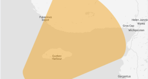
Weather advisory in effect for:
- White River – Dubreuilville
Winter weather travel advisory continues this morning.
Hazards: Lake effect snow off Lake Superior, with additional snowfall amounts of 5 cm possible.
When: Continuing this morning.
Discussion: Strong southwest winds are bringing lake effect snow bands from Lake Superior inland to areas near Dubreuilville early this morning. Peak snowfall rates of 2 to 4 cm in an hour or two are possible.
Travel will be impacted during this period, especially along Highway 17.
The snow will move out of the region later this morning.
Be prepared to adjust your driving with changing road conditions. If visibility is reduced while driving, slow down, watch for tail lights ahead and be prepared to stop. Visibility may be suddenly reduced at times in heavy snow.
For road conditions and other traveller information from the Ministry of Transportation, visit https://www.ontario.ca/511, https://www.twitter.com/511Ontario, or call 5-1-1.
Please continue to monitor alerts and forecasts issued by Environment Canada. To report severe weather, send an email to [email protected] or tweet reports using #ONStorm.
Jan 26, 2022 at 12:00
10:53 AM EST Wednesday 26 January 2022
Weather advisory in effect for:
- Wawa – Pukaskwa Park
Winter weather travel advisory in effect for this afternoon through Thursday.
Hazards:
Lake effect snow off Lake Superior, at times heavy, with total snowfall amounts of 10 to 20 cm possible by Thursday.
Wind gusts up to 80 km/h causing very low visibilities at times in blowing snow.
When:
This afternoon through Thursday morning.
Discussion:
Flurries in a stiff southwest flow off of Lake Superior are becoming more widespread today. The lake effect snow will become heavy at times beginning this evening, with peak snowfall rates of 2 to 4 cm likely in the strongest lake effect snow squalls.
Travel will be impacted during this period, especially along Highway 17.
Snow squall watches or warnings may be issued later today.
This lake effect snow is expected to taper off by midday Thursday.
Travel may be hazardous due to sudden changes in the weather. Be prepared to adjust your driving with changing road conditions. If you must drive, be prepared for areas of poor visibility. Visibility will be suddenly reduced to near zero at times in heavy snow and blowing snow.
For road conditions and other traveller information from the Ministry of Transportation, visit https://www.ontario.ca/511, https://www.twitter.com/511Ontario, or call 5-1-1.
Please continue to monitor alerts and forecasts issued by Environment Canada. To report severe weather, send an email to [email protected] or tweet reports using #ONStorm.
Jan 26, 2022 at 07:14
6:51 AM EST Wednesday 26 January 2022
Weather advisory in effect for:
- Wawa – Pukaskwa Park
Winter weather travel advisory in effect for today through Thursday.
Hazards:
Lake effect snow off Lake Superior, at times heavy, with total snowfall amounts of 10 to 20 cm possible by Thursday.
Wind gusts up to 80 km/h causing significantly reduced visibilities at times in blowing snow.
When:
Beginning this morning and lasting through Thursday morning.
Discussion:
Flurries will move into the region this morning. By this evening or overnight, lake effect snow will become heavy at times, with peak snowfall rates of 2 to 4 cm/h likely. Strong and gusty southwesterly winds will also reduce visibilities in blowing snow. Travel will be impacted during this period, especially along Highway 17.
This lake effect snow is expected to taper off by midday Thursday.
Travel may be hazardous due to sudden changes in the weather. Be prepared to adjust your driving with changing road conditions. If you must drive, be prepared for areas of poor visibility. Visibility will be suddenly reduced to near zero at times in heavy snow and blowing snow.
For road conditions and other traveller information from the Ministry of Transportation, visit https://www.ontario.ca/511, https://www.twitter.com/511Ontario, or call 5-1-1.
Please continue to monitor alerts and forecasts issued by Environment Canada. To report severe weather, send an email to [email protected] or tweet reports using #ONStorm.
Jan 25, 2022 at 23:16
10:17 PM EST Tuesday 25 January 2022
 Weather advisory in effect for:
- Wawa – Pukaskwa Park
Winter weather travel advisory in effect for Wednesday through Thursday.
Hazards:
Lake effect snow off Lake Superior, at times heavy, with total snowfall amounts of 10 to 20 cm possible by Thursday.
Wind gusts up to 80 km/h causing significantly reduced visibilities at times in blowing snow.
When:
Wednesday morning through Thursday.
Discussion:
Snow squalls are expected to weaken by Thursday afternoon.
Travel may be hazardous due to sudden changes in the weather. Be prepared to adjust your driving with changing road conditions. If you must drive, be prepared for areas of poor visibility. Visibility will be suddenly reduced to near zero at times in heavy snow and blowing snow.
For road conditions and other traveller information from the Ministry of Transportation, visit https://www.ontario.ca/511, https://www.twitter.com/511Ontario, or call 5-1-1.
Please continue to monitor alerts and forecasts issued by Environment Canada. To report severe weather, send an email to [email protected] or tweet reports using #ONStorm.
Orange Alert = Severe weather
Red Alert = Very dangerous and possibly life-threatening weather
For road conditions and other traveller information from the Ministry of Transportation, visit https://www.ontario.ca/511, or call 5-1-1.
Please continue to monitor alerts and forecasts issued by Environment Canada. To report severe weather, send an email to [email protected] or tweet reports using #ONStorm.
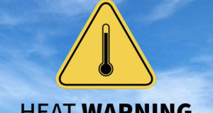
- Heat Warning (White River – Dubreuilville) - June 29, 2026
- Heat Warning (Chapleau – Missinaibi Lake) - June 29, 2026
- Heat Warning (Gogama – Foleyet) - June 29, 2026