Wawa-news.com Local and Regional News
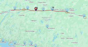
A low-pressure system will track east across Northern Ontario today with snow expected to begin this morning and continue through to tonight. Environment Canada warns that the “southerly flow off Lake Superior may enhance snowfall rates for some areas, leading to locally higher snowfall amounts.”
A snowfall warning is in effect for Wawa – Pukaskwa, Marathon to Nipigon. Snow, heavy at times is expected, 10-20 cm accompanied with strong winds with gusts of 50-60km/h will mean blowing snow and reduced visibilities.
Be aware that road closures may occur, and highways may close. Be prepared, watch for changing road conditions.

Latest posts by Brenda Stockton (see all)
- Hwy 11 (Longlac to Hearst) CLOSED - June 8, 2026
- LSPP Artist in Residence – Christian Chapman “Woodland Pop!” Workshop - June 8, 2026
- Monday Morning News – June 8 - June 8, 2026