Wawa-news.com Local and Regional News
Updated: July 29, 2026 at 6:25 p.m. Central Daylight Time (CDT)
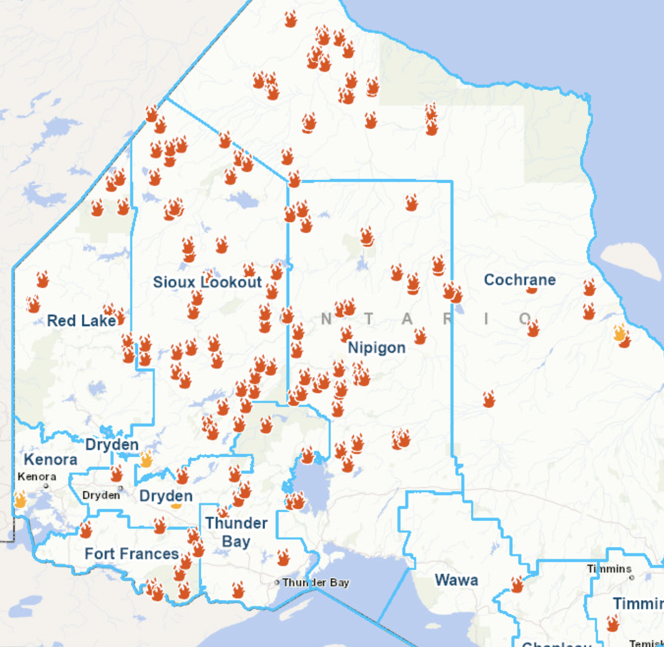 There were 3 new wildland fires confirmed in the Northwest Region by the evening of July 29.
- Dryden 54 (DRY054) is located approximately 7 kilometres west of Highway 599 between Paguchi Lake and Victory Lake. The 0.1-hectare fire is being held.
- Kenora 26 (KEN026) is located near the north shore of Clytie Bay in Shoal Lake. The 0.1-hectare fire is not under control.
- Sioux Lookout 105 (SLK105) is located in Lac Seul First Nation, between English River and Upper Grassy Bay. The 0.2-hectare fire is not under control.
At the time of this update there are 117 active wildland fires in the Northwest Region. Of those fires, 25 are not under control, 5 are being held, 5 are under control 82 are being observed.
Fires of note
Thunder Bay 36 (THU036)
- The fire is currently measuring 313,930 hectares and is not under control.
- Crews are extinguishing hot spots with pump and hose, supported by helicopter bucketing operations. These coordinated efforts are focused on securing the fire perimeter.
- Helicopter bucketing operations are supporting ground crews by delivering water to priority areas, helping to cool hot spots and reduce the potential for fire activity.
- Heavy equipment operators are constructing fire guards to create gaps in forest fuels, helping to limit fire spread and support containment efforts.
- Values protection plans are being developed by an Alberta Wildland Urban Interface (WUI) Team.
Brightsand Cluster – Dryden 34 (DRY034), Dryden 35 (DRY035), Thunder Bay 54 (THU054), and Thunder Bay 56 (THU056)
- Tomorrow, command of DRY034, THU054, and DRY035 will transition to the Incident Management Team currently assigned to THU036.
- Ontario and Alberta crews continue to make good progress un favourable weather conditions, working alongside heavy equipment operators and bucketing helicopters.
- DRY034 is currently measuring 44,954 hectares and remains not under control.
- DRY035 is currently measuring 22,461 hectares and remains not under control.
- THU054 is currently measuring 7,389 hectares and remains not under control.
- THU056 is currently measuring 7,947 hectares and remains not under control.
Atikokan Cluster – Fort Frances 14 (FOR014), Fort Frances 15 (FOR015), Fort Frances 38 (FOR038)
- Increased fire behaviour has been observed today as hot temperatures and limited rainfall have caused forest fuels to dry out.
- FOR014 is currently measuring 51,806 hectares and remains not under control.
- Firefighting crews are working from multiple locations along the fire perimeter, using a pump-and-hoseline system and working towards one another. Where crews meet, hoselines are tied in to create a consolidated fire perimeter.
- Helicopters continue to support suppression efforts by dropping water on hotspots and areas of active fire.
- CL-415 waterbombers provided suppression support throughout the afternoon.
- FOR015 has been more accurately remapped to 42,273 hectares and remains not under control. The lower number is a reflection of the mapping and ground-truthing of the perimeter by firefighters patrolling the consolidated hoselines.
- Crews are busy on the north side of FOR015 where fire behaviour has been more active as fuels dry out in the hot weather. Bucketing support from the helicopters is allowing the crews to make good progress in this area of the fire.
- FireRanger Crews on the west side of FOR015 continue to establish and consolidate hose line, patrol the established hoselines and are working inward to approximately 100 feet from the perimeter.
- FOR038, north of Crystal Lake, remains under control at 44.2 hectares in size.
- One Firefighter crew is working on hot spots while supporting demobilization.
Dryden 36 – Upper and Lower Moosehide Lakes
- The fire is currently measuring 1,707 hectares and remains not under control.
- Ontario FireRangers are working alongside Type-2 and Alberta crews, bucketing helicopters and heavy equipment operators in suppression operations.
- Low fire behaviour has observed in recent days under favourable weather conditions.
Sioux Lookout 72 – Cat Lake First Nation
- The fire is currently measuring 23,597 hectares and is not under control.
- FireRanger crews are making good progress on suppression efforts supported by bucketing helicopters targeting hotspots.
- Hand-held and aerial infrared scanning is being utilized to identify remaining hotspots.
- Minimal fire behaviour was observed today.
Highway 599 Cluster – Sioux Lookout 84 (SLK084), Sioux Lookout 86 (SLK086), Sioux Lookout 89 (SLK089)
- There has been no fire recent growth observed on cluster of fires.
- There are currently 120 personnel assigned to the incident, supported by five helicopters.
- Across all three fires, firefighters are using hand tools, pumps, and hose to extinguish remaining sources of heat.
- Helicopter bucketing operations were not required today due to the rainfall received this morning.
- SLK084 is currently measuring 4,796.6 hectares and remains not under control.
- SLK086 is currently measuring 5,644 hectares and remains not under control.
- SLK089 is currently measuring 7,190.1 hectares and remains not under control.

- Men’s Night Golf – Results of October 8th - October 10, 2026
- Two new student trustees begin their term at CSC Nouvelon - October 8, 2026
- SSM Police: Fraud Alert – Cellphone Service Provider Scams - October 8, 2026