Wawa-news.com Local and Regional News
Northeast Region
Updated: July 1, 2026 at 6:05 p.m. Eastern Daylight Time (EDT)
There were two new wildland fires confirmed in the Northeast Region today:
- Chapleau 8 measured 0.1 of a hectare. It was located approximately 27 kilometres south of Chapleau, east of the Sheppard and Morse road and has already been declared out.
- Wawa 8 was confirmed late this afternoon, measures 8 hectares and is located east of Hillsport and south of White Otter Lake. It is not under control at this time.
At the time of this update, there are 21 active wildland fires in the Northeast Region. Of those fires, 2 are not under control, 1 is being held, 1 is under control, and 17 are being observed.
Northwest Region
Updated: July 1, 2026 at 18:27 p.m. Central Daylight Time (CDT)
There were 4 new fires confirmed in the Northwest Region by the early evening of July 1.
- Sioux Lookout 57 (SLK057) is located approximately 41 kilometres east of Pickle Lake. The 5-hectare sized fire is not under control.
- Thunder Bay 32 (THU032) is located west of Smoothrock Lake in Wabakimi Provincial Park, approximately 42 kilometres northwest of Armstrong. The fire is not under control at 0.5 hectares.
- Thunder Bay 31 (THU031) is located east of Smoothrock Lake in Wabakimi Provincial Park, approximately 32 kilometres northwest of Armstrong. The fire is not under control at 0.1 hectares in size.
- Nipigon 21 (NIP021) is located approximately 58 kilometres east-southeast of Webequie First Nation in the Far North. The fire is being observed at 5 hectares.
There were 2 additional fires confirmed in the evening hours of June 30, following the previous update.
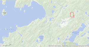
- Fort Frances 15 (FOR015) is located near Olifaunt Lake in Quetico Provincial Park, approximately 28 kilometres southeast of Atikokan. The fire is not under control at 10 hectares.
- Sioux Lookout 56 (SLK056) is located in a remote area, approximately 84 kilometres northeast of Pickle Lake. The 43-hectare fire is being observed.
At the time of this update there are 76 active fires in the Northwest Region. Of these fires, 31 are not under control, 2 fires are being held, 5 fires are under control and 40 fires are being observed. One fire was called out in the past 24 hours
Fires of note
Kasabonika Cluster
- 9 FireRanger crews, 8 fire management personnel, 4 helicopters and 1 fixed wing aircraft have been assigned to the Kasabonika Lake First Nation Cluster of Fires.
- Additional FireRanger crews are expected to join the firefighting effort in the coming days.
- Nipigon 16 (NIP016) has been re-mapped to 1,474.2 hectares. The fire’s status remains not under control.
- Fire behaviour has been reduced, following 9.4 mm of rainfall, over a 24-hour period, June 30. No overnight rain was recorded July 1.
- Nipigon 12 (NIP012) is located approximately 20 kilometres west of Kasabonika Lake First Nation and currently measuring 965 hectares.
- There are 3 additional active fires in the area surrounding Kasabonika Lake First Nation.
- Nipigon 13 (NIP013) is not under control and has been remapped to 298.0 hectares
- Nipigon 14 (NIP014) is not under control at 2 hectares
- Nipigon 15 (NIP015) is not under control at 0.1 hectares.
NOTAM in place – Kasabonika Cluster
There is currently a NOTAM in the area of wildland fire Nipigon 16 near Kasabonika Lake First Nation. This is over and above the standard airspace restrictions imposed by Section 601.15 of the Canadian Aviation Regulations (CARs) which state that the airspace around all active forest fires is restricted to forest fire suppression aircraft only, specifically airspace within 5 nautical miles, up to an altitude of 3000 feet above ground level.
Pilots are reminded that NOTAMs concerning forest fires can be found on NavCanada’s Collaborative Flight Planning Services under the ‘Weather and NOTAM’ tab, when flight planning.
Fort Frances 14
- Fort Frances 14 (FOR014) is located approximately 35 kilometres southwest of Upsala near Byers Lake. Discovered in the late afternoon of June 30, high winds and dry conditions saw the fire quickly grow to its present size of 1,510 hectares.
- Waterbombers were active on the fire today
- Crews are being mobilized to begin fire suppression on Fort Frances 10 at the earliest opportunity.
Sioux Lookout 21 – Wunnumin Lake First Nation
- Sioux Lookout 21 (SLK021) remains 357 hectares in size and is not under control.
- The fire is approximately 9 kilometres south of the Wunnumin Lake First Nation Airport.
- FireRanger crews continue to make progress, having encircled a spot fire to the west of SLK 021 with hoseline and establishing more hoseline on the fire’s western perimeter closest to the community.
- 6 FireRanger crews and 3 helicopters are assigned to SLK 021.
NOTAM in effect – Sioux Lookout 21
There is currently a NOTAM in the area of wildland fire Sioux Lookout 21 fire near Wunnumin Lake First Nation. This is over and above the standard airspace restrictions imposed by Section 601.15 of the Canadian Aviation Regulations (CARs) which state that the airspace around all active forest fires is restricted to forest fire suppression aircraft only, specifically airspace within 5 nautical miles, up to an altitude of 3000 feet above ground level.
Pilots are reminded that NOTAMs concerning forest fires can be found on NavCanada’s Collaborative Flight Planning Services under the ‘Weather and NOTAM’ tab, when flight planning.

- This Weekend at LSPP – Saturday, July 25 & Sunday, July 26th - July 25, 2026
- Northeast Forest Fire Update – July 24 - July 25, 2026
- Northwest Forest Fire Update – July 24 - July 25, 2026