Wawa-news.com Local and Regional News
Heavy rain, snow and strong winds expected tonight into Friday.
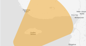
A developing low pressure system is expected to bring a mix of rain and snow to parts of Northwestern Ontario. Precipitation is expected to begin tonight before quickly intensifying early Thursday morning and then easing slowly throughout the day on Friday.
Throughout the event rain is forecast for communities closer to Lake Superior while higher elevations inland will likely see precipitation in the form of snow.
By Friday evening, snowfall accumulations inland could vary widely between 5 and 15 cm with some regions locally seeing higher amounts. Meanwhile rainfall amounts for communities close to Lake Superior including the city of Thunder Bay could be in the 30 to 70 mm range. Rainfall warnings may be issued as the event approaches.
In addition, strong easterly winds will affect the western shores of Lake Superior on Thursday, with gusts of 50 to 80 km/h.
For information concerning flooding please consult your local Conservation Authority or Ontario Ministry of Natural Resources and Forestry District Office. Visit Ontario.ca/floods for the latest details.

- Confederation College Approved to Deliver Instrumentation and Control Technician Apprenticeship Training - June 29, 2026
- Ladies Night Golf – June 24 - June 29, 2026
- Today at LSPP – Monday, June 29th - June 29, 2026