Wawa-news.com You can't hear the 'big picture'!
Apr 9, 2017 @ 19:39
3:51 PM EDT Sunday 09 April 2017
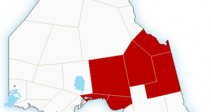
Special weather statement in effect for:
- Sault Ste. Marie – St. Joseph Island
- Blind River – Thessalon
- Espanola – Killarney
- Manitoulin Island
- Greater Sudbury and vicinity
- North Bay – Powassan – Mattawa
- West Nipissing – French River
Periods of rain will be followed by freezing rain Monday night.
Periods of rain are expected to affect portions of northeastern Ontario tonight and Monday. General rainfall amounts of 15 to 25 mm are likely. However, a few areas may receive higher amounts due to potential thunderstorm activity.
On Monday evening, temperatures are expected to fall below the freezing mark resulting in freezing rain.
The area is being monitored for potential rainfall or freezing rain warnings.
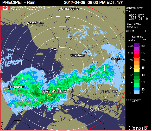
Montreal River Harbour Radar Imagery from 8 p.m. Sunday evening.
3:33 PM EDT Sunday 09 April 2017
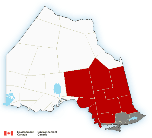
Freezing rain warning in effect for:
- Wawa – Pukaskwa Park
- White River – Dubreuilville
- Agawa – Lake Superior Park
- Searchmont – Montreal River Harbour – Batchawana Bay
- Sault Ste. Marie – St. Joseph Island
- Chapleau – Missinaibi Lake
- Gogama – Foleyet
Freezing rain is expected or occurring.
Periods of freezing rain are expected to begin late this evening or overnight as temperatures drop below the freezing mark.
The freezing rain will persist for several hours before ending early Monday morning.
Take extra care when walking or driving in affected areas. Slow down driving in slippery conditions. Watch for taillights ahead and maintain a safe following distance.
Freezing rain warnings are issued when rain falling in sub-zero temperatures creates ice build-up and icy surfaces.
6:27 PM EDT Sunday 09 April 2017
Rainfall warning in effect for:
- Searchmont – Montreal River Harbour – Batchawana Bay
- Chapleau – Missinaibi Lake
- Gogama – Foleyet
Rain, heavy at times is expected. The frozen ground has a reduced ability to absorb this rainfall.
An area of showers and thunderstorms is affecting areas north of Sault Ste. Marie and is expected to continue into tonight.
The most intense rainfall is expected to stretch from just north of Sault Ste. Marie towards the town of Gogama. Cities such as Sault Ste. Marie, Chapleau and Elliot Lake will likely remain just outside of this zone and should see lesser amounts.
Total rainfall amounts of 25 to 40 mm are likely tonight, especially in areas that receive several thunderstorms.
Localized flooding in low-lying areas is possible. Heavy downpours can cause flash floods and water pooling on roads. If visibility is reduced while driving, slow down, watch for tail lights ahead and be prepared to stop. Avoid driving through water on roads. Even shallow, fast-moving water across a road can sweep a vehicle or a person away.
Rainfall warnings are issued when significant rainfall is expected.

- Friday Morning News – April 19th - April 19, 2024
- Thursday Morning News – April 18 - April 18, 2024
- Wednesday Morning News – April 17 - April 17, 2024